Brownseys Blography

This is an amateur blogger's camera biography - a 'blography' of some of the pictures it has captured as I've accompanied it on walks in the UK. If you enjoy it half as much I enjoy taking pix I'll be a very happy blogger!

Blog Posts: Sussex, Essex, Kent, North Wales, Dorset, Cornwall, Suffolk, Norfolk, Arran, Lincs, Isle of Wight, Skye, Northumbria, Pembrokeshire

Tuesday 2 June 2009

Sussex

I used to travel by train every Saturday on the 'Bedpan' line (Bedford to St Pancras), and was often tempted not to get off at my London destination but to go all the way to the end of the line, to Brighton. So when I was asked what I wanted to do for my birthday, I decided a day trip to Brighton would be just the ticket!

When the big day arrived the sun was shining and the sky was blue, which was good, but not that unusual for May, with summer just around the corner. We duly caught the train and in no time at all we arrived at Thameslink Station, where I took great delight in staying put in my seat! From that point onwards the journey became less familiar, so more interesting. It only takes around 2 hours to get to Brighton but the journey was just beginning to lose it's novelty value when a brood of bawdy 'hens' burst into our carriage giggling, and adding some amusing and temporary distraction. The slogan on their bright pink tee-shirts suggested this clutch of chicks had every intention of making sure the 'bride-to-be' would make the most of her last weekend as a singleton. But when the train let them loose on an unsuspecting Brighton public to have their fun, it was also our turn to have some, but fun of an altogether different kind!

We left the station and headed straight for the sea-front, keen to see what Brighton beach had to offer us in terms of fun - which for us is, of course, photography. The first and most obvious photo opportunity was the poignant sight of the now derelict West Brighton pier, constructed in 1866, closed to the public in 1975, and devoured by fire in 2003. All that remains is the twisted metal skeleton of the end section, left abandoned in the ocean seemingly without repair or raison d'etre - apart from being excellent photographic material of course - and the roosting ground for tens of thousands of Starlings who regularly pull in a crowd by performing their synchronised swirling, swooping and cartwheeling displays at sunset. Having wanted to see this spectacle for some time, I was looking forward to a sunset with an exciting difference!

The Kings Road arches that line the Lower Esplanade also provided us with some fun, and not just of the photographic variety. There was indeed the occasional vertical boat and strategically placed bicycle waiting to be immortalised on 'chip', and more than a few arty archway galleries with their open door invitations. But it was also lunchtime so we decided to check out one of the attractive archway eating establishments. Soon we were tucking into tasty toasted cheese Ciabattas, accompanied by an amplified helping of soundtrack, as the evening entertainment band began turning up, tuning up and ''testing ... one, two, three'', throughout the meal, pausing only when deafening feedback made it impossible to continue ! With our stomachs full and our ears still just about intact we decided to head off into the famous 'Brighton Lanes' to hob-knob with the artisans and tussle with the tourists!

The Brighton Lanes' historic quarter, once a fishing town called Brighthelmstone, is now a maze of twisting alleyways (known to locals as 'twittens'), offering an extraordinary mix of shops from quirky to designer, antique to contemporary and everything in between. To liven the experience of the Lanes you can shop to the accompaniment of live music, to jazz, and buskers. If you're all shopped out and need to collapse in a weary heap you can do that in style too, in one of the many trendy coffee bars and colourful cafes. After experiencing both, we decided to explore another quarter of town, one where the skyline is full of minarets and domes.

The unmistakable skyline that now dominates Brighton belongs, of course, to the famous Royal Brighton Pavilion. This opulent seaside home was remodelled in Indian style by John Nash between 1815-1823 for George, Prince Regent and later George IV. After the death of George IV in 1830, his successor King William IV also stayed in the Pavilion on his visits to Brighton. However Queen Victoria disliked Brighton and the lack of privacy the Pavilion afforded her on her visits there (especially once Brighton became accessible to Londoners by rail in 1841) and after her last visit to Brighton in 1845, the Government planned to sell the building and grounds. The Brighton Commissioners and the Brighton Vestry successfully petitioned the Government to sell this Bijou residence to the town for £53,000 in 1850!

If you've assumed that the Brighton Pavilion is 'all external show and no internal substance' then you might want to think again. The interior is a lavish combination of Indian and Chinese-style decorations with magnificent furniture and furnishings, adorned by gilded dragons, carved palm trees and imitation bamboo staircases. And the daring and inventive colour schemes used throughout are like an explosion in a paint factory! A truly unique eclectic style that mixes Asian exoticism with English eccentricity. Unfortunately there are no photos to illustrate this, as no cameras were allowed, but the images remain in our memory albums.

Once we'd had our fill of lavish Chinese carvings and luscious carrot cake in the cafe, we made our way back to the beach for a walk along the pier - Brighton Central Pier, that is, not the burnt bereft bit of the West Pier! But by the time we had reached the seafront the whole place had taken on a new and more dramatic appearance altogether ... .

Sadly the sky was not full of swooping Starlings, so true to form I was going to miss yet another 'must see' widlife spectacle. But the sky was about to put on it's own display. Having turned from blue to steely grey, the sky was now full of dark moody clouds racing across it with threatening attitude. Storm force gusty gales had replaced the fresh breeze of the morning, transforming the placid sea into a seething mass of churning water. Huge rolling waves crashed heavily onto the beach and smashed into the pier and jetty, sending explosions of sea-spray and volumes of squeals sky high, as the sea repeatedly deposited itself on unsuspecting onlookers. Great fun watching and great fun to photograph too! That is, until we took one risk too many, and maybe one step too far in our attempt to get closer to the spectacular performance - resulting in a drenching, and giving mother nature the last laugh on our fun day out in Brighton.

Sunday 31 May 2009

Essex

What do you do when you live in the middle of the UK, you're feeling landlocked, the sun is shining and you only have a few hours to spare? You head off to Walton-on-the-Naze of course! The last time I went to Walton my daughter was the same age as her daughter is now, and my lasting memory of that occasion was when a rogue wave hurtled over the sea wall, drenching the poor mite as she was walking along it! Not wishing to repeat that scary episode, we set off to Walton with camera, rather than daughter clutched in my hand.

Walton likes to be identified as 'the friendliest resort in Britain'. Not sure how they reached that conclusion, but come to think of it, I did speak to an extremely helpful and friendly shop assistant when buying some postcards, so maybe there's some truth in it! What I can vouch for is that Walton seems to have retained all the charm of a small traditional Victorian seaside resort, without seeming to lose any of it's appeal to visitors of all ages. But it also has the added benefits of being home to the UK's second longest pier, having a cliff full of tiered rows of beach huts and it's own very special Nature Reserve. Oh, and it's been designated as a Site of Special Scientific Interest too!

But the history of Walton has to begin millions of years ago, even before that of many other towns. This is because the area to the north that is said to lend the town it's name - the promontory known as the 'Naze' - is rich in fossils, particularly those from a warm ancient sea. The soft eroding cliffs form one of the finest geological sites in Britain and for that reason are a Site of Special Scientific Interest. At the base of the cliffs is London Clay which is 54 million years old and it's overlaid with Red Crag, 2 million years old! This sandy deposit contains a large number of fossils, including shells, sharks teeth and bird skeletons.


There is also clear and copious evidence of early man present from both the Palaeolithic and, more commonly, the Neolithic periods. Indeed the area seems to have supported a large and industrious population in the New Stone Age.

So, after we'd checked out the photogenic beach huts, the famous long pier and the infamous and ineffective sea wall, we aimed for the prehistoric, Stone Age cliffs - for a walk, to check out the nature reserve, to do some beach-combing, and maybe even to find some fossils ... .

The Naze stretches northward from Walton for 3 miles and is currently a public open space. The nature reserve is located near the end of the Naze and can be reached along the public footpath which stretches along the cliff tops from the Naze Tower. It's owned by the Essex Wildlife Trust and named after the late John Weston, a leading Essex naturalist. The dense scrub of hawthorn, gorse and brambles provides cover for numerous animal species and nesting birds, including Lapwing, Sedge and Reed Warblers and the occasional rare vagrants. It also acts as a important landfall and wintering ground for migrating birds, such as the Firecrest, Brent Geese, Godwit, Redshank, Shelduck, Teal and Avocet. In summer the cliffs provide secure sites for sand martins, and being so close to the shore the reserve also attracts shore loving insects including Emperor and Cream Spot Tiger moths. The shore itself is a feeding ground for waders, gulls and terns, and in addition there are nationally important numbers of Widgeon, Ringed Plover, Curlew and Dunlin. During migration in the Autumn and Spring the Naze is a prime bird watching site. Curlew Sandpipers are regularly seen along the beach with Gannets and arctic Skuas passing offshore.

Just behind the beach, Hamford Water and the Walton Backwaters offer tidal creeks, mudflats, islands, salt marshes and marsh grasslands to a plethora of wildlife. This area is recognised internationally as an important breeding ground for Little Terns. It also supports communities of coastal plants which are extremely rare in Britain, including Hog's Fennel. All of which can best be viewed from the footpath.

We chose to walk along the beach rather than the public footpath, an arbitrary decision which we later learned would prevent us from circling back through the reserve on the footpath, but one which we didn't regret anyway! Walking along the narrow strip of sandy beach was like walking along a sand spit, sandwiched as it was between the sea to our right and the creeks and channels to our left. Sadly I missed the opportunity to find a fossil as the tide was in. And we probably missed some interesting bird-life by choosing the beach route over the footpath, but it offered us instead pretty shells, pretty views over to Harwich, pretty stunning photographic material and a pretty good workout too!

With daylight and our energies fading fast, we decided it was a good time to leave Walton, and to drive further down the coast to catch the sunset. We found just the place.

Burnham-on-Crouch lies on the north bank of the tidal River Crouch. The town is small and quaintly pretty with many listed buildings. But it's Burnham's waterfront location that makes it such an attraction, and one that has historically been the mainstay of it's economy, firstly as an important ferry port, then as a fishing port and latterly as a major centre for yachting. The annual sailing event known as 'Burnham Week' attracts many visitors to this very popular and picturesque maritime area.

Arriving shortly before sundown, we managed to find a waterfront seat outside a watering hole. All we had to do was relax and wait ... and our patience was rewarded with an already amazing river scene backlit by the bright orange glow of the sun, silhouetting the jetties and boats before slipping into the water. A fitting end to an impromptu but impressive day on the Essex coast.

Friday 29 May 2009

Kent

This is Carlton House, Seaview Terrace, Margate, Kent. It's where I spent a few very happy holidays as a young child, half a century ago! Last year I indulged in a nostalgic day trip there, travelling back in time and memories as well as distance, to remember it as a child, but through the eyes of an adult.

Carlton House, or at least the right hand corner of it, was owned by The Salvation Army back in those days. It was offered as a sort of perk, holidays at budget prices, and eligibility restricted to 'commissioned officers' and their children only. But it offered a whole lot more. It provided a family, friendly holiday environment for people with very similar backgrounds and lifestyles, somewhere where children were guaranteed to make new friends instantly and where adults could relax, secure in the knowledge that their children's safety was a 'given' and that they were (purportedly) mixing with the right crowd!

We lived in London in those days, so it wasn't a lengthy journey, even without the M25 (or perhaps because of it)! But I clearly remember the approach road into Margate. This is probably because my very special parents were always keen to perpetuate the eager anticipation and excitement of their 3 young children in the back of the car. This was achieved by singing lines from the old Irving Berlin song "We joined the navy to see the world, and what did we see, we saw the sea", followed by questions such as 'can you smell the sea yet', all designed to invoke a happy holiday atmosphere and to 'keep us going' during the last stage of the journey.

The same lyrics were heard en route to Margate last year, but, of course, only in my head. However there was visible and audible excitement in the car as we approached Margate town centre, as snatches of hazy recognition somehow found their way through 50 years of memories buried deep in my brain, and flashed before my eyes. Recognition of street corners and junctions, local shops and buildings ... but of one in particular ... Dreamland!

Dreamland opened in 1920 and is home to the oldest operating roller coaster and first recorded amusement park ride, the Scenic Railway. This iconic place quickly became a popular tourist attraction, and by the time I first visited in the 1950s it was already a mecca for the new teenage culture which was emerging in Britain at the time. With popular music hitting our shores and a teenage fashion industry hot on it's heels, young people had their own identity for the first time. And with Dreamland on the scene, they had their own entertainment too. Whilst I didn't fit into the teenage category, I vividly recall the excitement of walking through the entrance 'tunnel', and entering a new and exciting experience, a visual and auditory sensory explosion! The thrills of the Scenic Railway as it rattled round the track on it's wooden structure, the awesome sight and height of the double big wheel, colourful stalls brimming with the promise of prizes, the screams of fear and delight from white knuckle rides, the magic of spinning candy floss machines; all these made Dreamland a very new, special and magical experience for me. It was also the place where my teenage sister first fell in love.

Sadly Dreamland has now closed its doors, and in 2008 the Scenic Railway fell victim to an allegedly suspicious fire, where it was largely destroyed. But like a Phoenix from the Ashes, both the railway and the site are set to rise once again. Following a chequered history of re-sales, re-openings, re-namings, re-invention, removal of rides and regeneration schemes, Dreamland now has the protection of Listed Building status and the sterling support of a National 'Save Dreamland Campaign' (which I must join!).

Margate, like many Victorian British seaside resorts, went through a major decline when cheap air travel, foreign package holidays and guaranteed sun was made available to holiday makers. But now the metaphorical tide seems to be turning on the seafront. On my recent nostalgic trip the central beach was once again alive with day trippers, sun worshippers, family outings, contented children and people taking pleasure in all the traditional attractions of a British resort, from bingo to beach-balls, cockles to cornets, and postcards to paddling.

We walked along what they now call Margate pier (which looks like a jetty), an industrial concrete structure, built as part of the harbour construction in 1810, and now doubling up as a place for artisans to display and sell their arts and crafts. But my childhood memories are of an extensive and impressive Victorian pier, built in 1855 and bizarrely known as the Margate Jetty! Whilst it stood the test of time for 120 years, this once grand wooden structure, like many others around our coast, succumbed to the ravages of fire, in 1978, and is no more!

We then took a walk across the beach, past a colourful and strangely familiar children's swing park (could they really be the same swing-boats and roundabouts I played on in 1957?), past beach volley-ball games, past Asian families chatting in family groups, clad in their beautiful saris whilst knee deep in the sea, past sandcastles, buckets and spades and the boating pond, until we reached the quieter, western end of Margate, and Carlton House.

It was smaller than I remember of course, and smarter, now more 'chic' than shabby. Gone were the coloured lights strung across the (now freshly painted) balconies, but still alive were the memories of going to sleep in a bedroom with a lit-up balcony overlooking the beach! The fuschia bush which had stood guard by the door had long since gone, but the brass plaque identifying 'Carlton House' was still in situ, and it was polished. Whilst taking photos down this memory lane, we were approached by a friendly resident of Carlton House who was intrigued to know why his house was being photographed. After confirming that he knew the history of his house, he informed us that the terrace was now privately owned, but still very much loved, which was music to my ears!

The next half hour was spent indulging in a plethora of memories as I retraced my steps from Carlton House, down the ramp where each day, my metal spade noisily scrapped the concrete as I skipped down the slope and onto the beach, where so many happy days were spent indulging in the simple childhood pleasures of making sand-pies, building sandcastles and paddling in the sea.

A couple of miles up the beach, and half a century later, we arrived at Cliftonville, the east end of Margate. This area was eerily deserted, and showed signs of still suffering from the decline, as if the metaphorical tide had yet to turn. But once more I had a flash of recognition as we walked past the slightly shabby but beautifully located sunken Winter Gardens. With the memory of comedic repartee and audience laughter still ringing in my ears, we left to take one last walk to the harbour, to buy a tray of cockles and mussels for our lunch, and to collect a bag of huge whelks for my collection from the (incredibly pungent) harbour beach, before driving further up the coast.

We intended our next stop to be Herne Bay, as neither of us had been there before. But a few miles before we reached it, a signpost to Reculver Towers caused us to take a small detour to check out a photo opportunity. Reculver was originally a camp and fortification created by the Romans as a station to oversee and protect one mouth of the channel which separated the Isle of Thanet (43 AD) from the mainland. But it functioned again during the 3rd century when Saxon pirates began raiding the region. As early as 210 AD, a fort was built with a 15 foot high wall. The fort is believed to have been abandoned in 410 AD when Roman troops left Britain. In 669 AD, the fort became the site of a Saxon church. St. Mary's Church, as it was called, became a navigational point for sailors, with two prominent towers known as "Twin Sisters". In light of their usefulness, the towers were allowed to remain when, in the 19th century, the church was demolished. Armed with some new historical facts and picturesque photos, we moved on to Herne Bay.

Herne Bay is a quiet little seaside town, which began as a small shipping community, receiving goods and passengers from London en route to Canterbury and Dover. It rose to prominence as a seaside resort during the early 19th century after the building of a pleasure pier and promenade by a group of London investors, and reached its heyday in the late Victorian era. Its popularity as a holiday destination has declined over the past decades, as was the case with Margate, but regular flooding has prevented the town's redevelopment, and therefore it's comeback. However, Herne Bay lays claim to the world's first freestanding purpose-built clock tower built in 1837, and until 1978, the town had the second-longest pier in the UK. It also has what must be one of the longest sea defence jetties in existence, which we can personally vouch for having walked along it from beginning to end! But in it's 'defence' it also provided excellent views over Herne Bay seafront. Our last port of call on the North Kent coastline was to Whitstable, home of the Oyster, and a whole lot more.

Whitstable harbour was built in 1832 by the Canterbury and Whitstable railway company in order to serve the "Crab and Winkle" line, the world's first passenger railway service. The railway has since closed but the harbour still plays an important role in the town's economy. Oysters have been collected in the Whitstable area since at least Roman times, and after a period of decline, the oyster fishery industry is now thriving again, and freshly caught shellfish are available throughout the year at several seafood restaurants and pubs in the town. The harbour fish markets are popular with locals and visitors alike, and a restaurant is also situated in the harbour, ready to serve up the day's catch. We enjoyed such a meal, eating 'al fresco', whilst listening to live music, watching people and drinking in the sights, sounds and smells of this bustling little harbour. There's a small market too, perfect for buying all the things you never realised you needed. A place to feed all your senses.

The Town of Whitstable grew from the main road to Canterbury, now known as the high street, and a network of alley-ways developed as local residents needed greater access to the sea. The multitude of alleys also served as convenient escape routes for smugglers, as Whitstable was, like most Kentish coastal towns, awash with the illegal trade in tobacco and spirits, as well as people during the Napoleonic wars. These alley-ways each have their own histories. for example, Squeeze Gut Alley, once known as Granny Bell's Alley, was so named due to the fact that a grandmother of sixteen children lived there, and the reason for its present title quickly becomes clear as you try to pass through it! The walls on each side loom high and dark as the alley bottle-knecks at the Island Wall end. According to history, the alley way may also have got its name from a game local boys once played with a potentially very unamused overweight policeman who was unable to pursue them through this confined space. Coastguard's alley is where the coastguards built their quarters in an attempt to combat Whitstable's once thriving smuggling trade, and Collar's Alley is where, in the great freeze of 1895, dozens of children would run down every morning to go to Mr Collar's store, where food, cocoa, and warmth were supplied free of charge.

Follow your nose in Whitstable and it will lead you to the sea. Whether you take the main route through the town or enjoy haphazard progress through quiet lanes and alleyways with their eccentric names, you'll end up at the harbour. Here, sailing boats wait for their chance to skim the waves and, from the shelter of the harbour walls, boats prepare for their next mission. I enjoyed my own nostalgic mission in Kent, but it barely scratched the surface of this lovely county.

Thursday 21 May 2009

North Wales

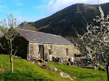
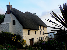
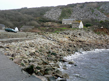
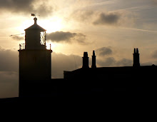
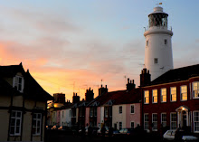
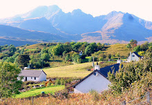
When we first considered taking a holiday in Snowdonia we were both drawn to the idea of being based in a remote area surrounded by mountains. This was probably driven by a natural instinct to avoid the main tourist areas. On the other hand we didn't want to be so far off the beaten track that our explorations would be restricted or reduced, in terms of travel time and ease of access. What we found surpassed all expectations, and involved no compromises! Our idyllic cottage was called Ty Maen ('My House'), a converted stone barn nestled in the tiny village of Nant Peris in the heart of Snowdonia, with Snowdon rising steeply to the right side, and The Carneddau mountain range to the left.

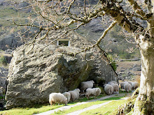
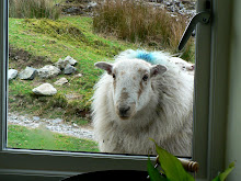
For added interest (as if any were needed!) our neighbours up the lane regularly passed by our cottage, often pressing their noses against the window to see what we were doing. I often wonder how Frank is doing. Frank wasn't what you'd call a looker. He had an untidy, shabby appearance and wore a coat that had seen better days. That's why we called him Frank, short for Frankenstein - friendly sort of sheep though!

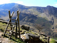
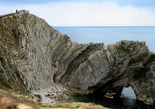
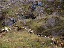
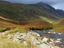
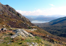
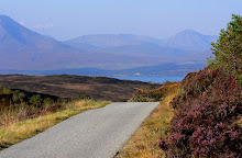
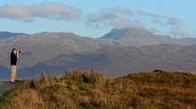
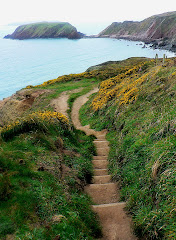
Our first mountain trek was described in the book as 'A Taming Walk in the Devil's Kitchen.' As it was just a 10 minute drive away around the base of a mountain close to Ty Maen, our cottage, it seemed an ideal walk. Actually we could have accessed it without getting in the car at all! Had we climbed up to the summit of Glyder Fach (994m), crossed over the top, and looked down the other side we would have seen Cwm and Llyn (mountain and lake) Idwal laid out before us. We did attempt this climb later in the week, but that's another story ... .

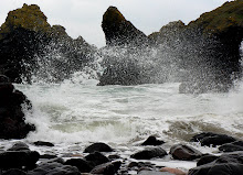
Idwal is said to be the 'haunt of demons, inspiring murderous thoughts, environed with horrible precipices,' and indeed in the 12th century Idwal, son of Owain Gwynedd was brutally murdered by Dunawd, in whose care he had been entrusted. We didn't see any devils or demons, or have any murderous thoughts (that I remember), mind you, when huge dark menacing clouds rolled over the mountains and a heavy mist hung over the valley, the place did take on a more sinister appearance ... and come to think of it, it was 'environed with precarious precipices' but the ones we saw had extreme sport fanatics dangling from them!

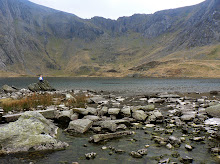
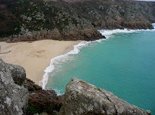
I preferred the alternative description of Cwm Idwal, 'the most perfect hanging valley in Snowdonia, a fine place to study geology and nature and to see many rare species of Arctic plants; a legacy of glaciation from the last ice age'. It was also a peaceful, stunning, remote and unspoilt place in which to take our first walk of the holiday.

The route started with a gentle walk past rocky glacial deposits to Llyn Idwal, a picturesque lake filling the basin of this perfect u-shaped valley, overlooked by a 360 degree panorama of mountain peaks. Following the path down the left side of the lake we continued forwards and upwards past the rock climbing grounds of the Idwal Slabs, stopping to watch in awe, even disbelief, at climbers laden down with all manner of equipment needed to get them up the sheer rock face and down again in one piece, and to give them the adrenaline and achievement rush they were seeking. We pursued our flatter, gentler but still challenging route past them, climbing up and around Cwm Idwal, where we were rewarded with remarkable views over the valley. Our return route was diverted downwards when we hit an obstacle that I didn't wish to overcome - the trail had been commandeered by a deep crevice cut out of the mountain side by a steep and impatient waterfall. It would have been a step too far, too deep, too steep and too wet for me, so we descended via a gentle slope back to the lake, stopping for more photos of this very pretty valley.

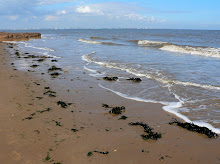
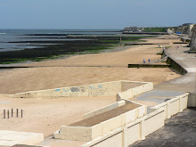
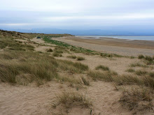
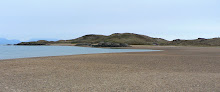
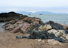
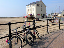
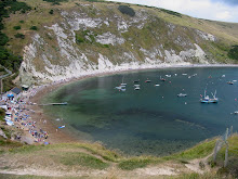
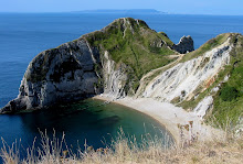
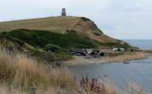
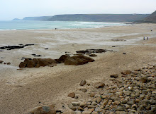
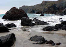
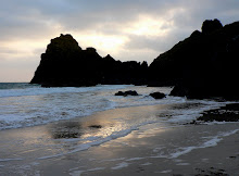
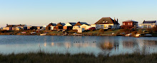
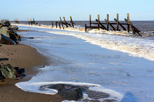
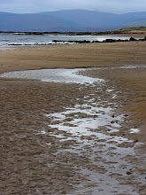
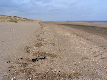
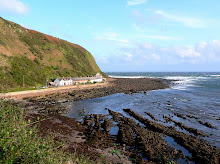
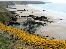
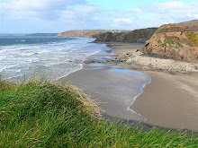
The following day we decided to tour around the Isle of Anglesey, clockwise. Our first stop of the day was on the south coast, and it was very nearly our last stop! After driving along the winding road through Newborough Warren and Forest we eventually reached the car park, just behind the beach on Llanddwyn Bay. The beach was beautiful. Wide, sweeping, with pale sands, fringed by the forest and grassy dunes and with misty views of Snowdonia on the horizon. We could see Llanddwyn Island ahead of us in the distance, jutting out from the beach into the sea, and knew it was possible to walk across to it, so that was our aim. However, distance can be deceptive in such landscapes and though we knew it would take a while to reach it, we had a feeling it would be worth the time and effort. We were right.

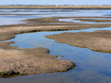
Llanddwyn Island is a magical place, with rolling dunes, large rocky outcrops, mudflats, saltmarshes and a handful of historic buildings on it, Snowdonia views beyond it and a romantic legend 
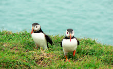
behind it. If that were not enough it is also part of the Newborough Warren National Nature Reserve, with a wide range of plants, nesting seabirds, and the unusual breed of Soay Sheep. It's not quite an island, and remains attached to the mainland at all but the highest tides.

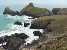
As you approach the 'island' there are several large rocks in the sand. These are pillow lavas, part of the Precambrian Gwna Group, formed by undersea volcanic eruptions; as the hot molten rock met the cold sea-water a balloon-like skin was formed which then filled with more lava, forming the characteristic pillow shape. These rocks extend down much of the length of the island, giving it it's interesting rolling topography.

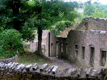
The name Llanddwyn means 'The Church of St Dwynwen'. She is the Welsh patron saint of lovers, making her the Welsh equivalent of St Valentine. She lived during the 5th century, fell in love with a a young man named Maelon but rejected his advances. This, depending on which story you read, was either because she wished to remain chaste, or because her father wished her to marry another. She prayed to be released from the unhappy love and dreamed that she was given a potion to do this, however the potion turned Maelon to ice. She then prayed that she be granted 3 wishes, 1. that Maelon be revived, 2. that all true lovers find happiness and 3. that she should never again wish to be married. She then retreated to the solitude of Llanddwyn Island to follow the life of a hermit. Pilgrimages and offerings were made to her holy well and shrine on the island such that it became the richest place in the area during Tudor times. This funded a substantial chapel that was built in the 16th century on the site of Dwynwen's original chapel. The ruins of this can still be seen today.

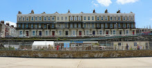
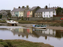
When we eventually tore ourselves away from this idyllic spot, it seemed that we had to rush the rest of the Anglesey coastline to fit everything in, but the truth was that nothing matched up to what we'd seen and experienced at Llanddwyn! That said, we continued clockwise round the coastline, stopping briefly to reflect on a little town called Aberfraw, as it had been advertised as a place worth seeing. No reflection on the good folk of Aberfraw, but reflections was all there was to see - pretty coloured cottages lined up on the river bank being reflected in the water!

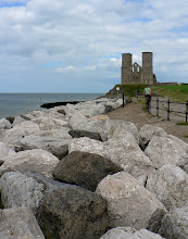
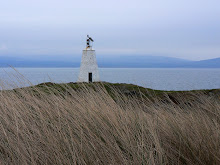
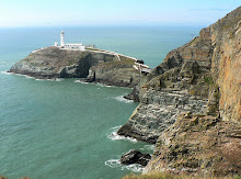
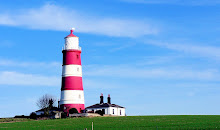
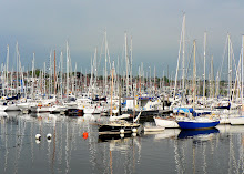
Heading up the coast we crossed over to Holy Island to visit Holyhead, major ferry port, and essential link to Ireland. After a colourful walk through the marina, and a tasty snack in the cafe overlooking the beach front we set off to South Stack for a bracing walk along the coast path to check out the famous Lighthouse on South Stack Island. The lighthouse has warned passing ships of the treacherous rocks below since its completion in 1809. The 91ft lighthouse is visible to passing vessels for 28 miles, and was designed to allow safe passage for ships on the treacherous Dublin-Holyhead-Liverpool sea route. It provides the first beacon along the northern coast of Anglesey for east-bound ships. But until 1828 when an iron suspension bridge was built, the only means of crossing the deep water channel on to the island was in a basket which was suspended on a hemp cable. The suspension bridge was replaced in 1964, but by 1983 the bridge had to be closed to the public, due to safety reasons. A new aluminium bridge was built and the lighthouse was reopened for public visits in 1997. Thousands of people flock to the lighthouse every year.

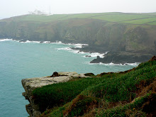
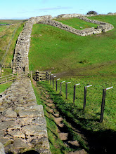
There are over 400 stone steps down to the footbridge, and the descent and ascent provide an opportunity to see some of the 4,000 nesting birds that line the cliffs during the breeding season. The cliffs are part of the RSPB South Stack Cliffs bird reserve, based at Ellin's Tower above, on the Anglesey Coastal Path. From this vantage point we enjoyed superb views of this rocky coastline, and the rocky island of South Stack.

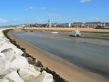
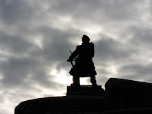
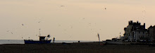
By the time we reached the peaceful little village of Moelfre on the north of the island, the sun was low in the sky, and energy levels low in our systems. After taking our fill at the local hostelry we took a brief walk along the Anglesey Coastal Path to see what Moelfre had to offer. It was apparent that Moelfre has a lot to be proud of, and is well known in many parts of the world as the home of one of the finest and renowned lifeboat stations in the world. The bravery of the men that have manned the boats over the years has been exceptional, with many bravery medals being won by a multitude of lifeboat men. A fine bronze statue of Dic Evans, Moelfre's hero and one of the most decorated RNLI Lifeboat Coxswains, stands 7 foot proud as testimony to Moelfre's history of heroism. Dic Evans received his first medal in 1950 when called out to the Hindlea of Cardiff when it was in distress in a hurricane force wind gusting to 104 miles per hour. Thanks to his bravery all the crew were rescued.

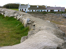
Our short walk and exploration of this 'little town with a big claim to fame' came to an end as we approached the photogenic picture postcard row of whitewashed stone cottages overlooking the tiny porpoise-shaped island of Moelfre just off shore, home to many sea-birds and apparently also to the occasional porpoise passer-by! But with the light fading fast it was time to head off back towards the Menai Bridge and Mainland, with the briefest of stops at Beaumaris for a glimpse of the Castle.

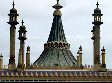
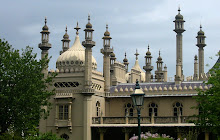
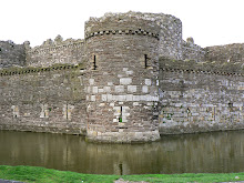
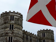
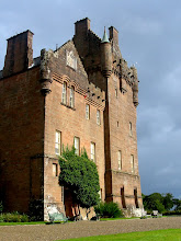
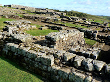
Beaumaris Castle, begun in 1295, was the last and largest to be built by King Edward I in Wales. Raised on an entirely new site, without earlier buildings to fetter its designer's creative genius, it is possibly the most sophisticated example of medieval military architecture in Britain. It is undoubtedly the ultimate "concentric" castle, built with an almost geometric symmetry. Conceived as an integral whole, a high inner ring of defences is surrounded by a lower outer circuit of walls, combining an almost unprecedented level of strength and firepower. Before the age of cannon, the attacker would surely have been faced with an impregnable fortress. Yet, ironically, the work of construction was never fully completed, and the castle saw little action apart from the Civil War in the 17th century.

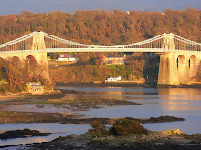
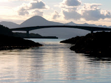
Just a few miles further round our 'clockwise tour' of Anglesey we were back at the Menai 
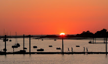
Bridge, where we were treated to a stunning display by the sun casting it's golden glow over the Menai Straits before it disappeared out of sight, and we disappeared out of Anglesey.

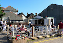
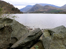
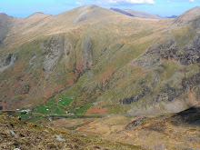
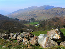
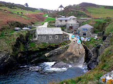
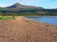
The following day we decided to stay local and see what Llanberis had to offer. The town is a riot of colour, with every building in the High Street painted a different colour of the rainbow! A pretty little town with a lot of attractions to offer visitors. Thankfully we saw it at it's best - off peak, uncrowded and on form! Running alongside the town, are the even prettier twin lakes of Llyn Padarn and Llyn Peris. These cut through the mountain range creating the Llanberis Pass, in an area noted for its rugged beauty, and which just happens to be where Nant Peris, and Ty Maen are located.

The Llanberis lake railway runs along the northerly shore of Llyn Padarn with the main station located in the Padarn Country Park, across the valley from the town amidst unspoilt woodland and a range of tourist attractions related to the slate industry. The tiny locomotives used on the line have all seen service in Dinorwic Quarries at one time or another where they once hauled slate wagons in the quarry. Commercial Quarrying in the Elidir mountain began at Dinorwic in the late 19th century, but the quarry closed in 1969 and was converted into the National Slate museum, courtesy of the Heritage Lottery Fund.
Both the railway and the museum sounded like a fun and different way of seeing and understanding the local area, so we were soon 'all aboard' and chuffing and chugging our way around the lake!

The train ride was a great success, providing panoramic views over the lake, and even a stop along the way to capture them on camera. We conveniently alighted from the train at the entrance to the National Slate Museum. Only it was not so much a museum as a pocket of history, looking for all the world as if the quarrymen and engineers had only just put down their tools and left the courtyard for home! As well as bringing the history of slate mining alive, it was also a minefield of photo-opportunities, and one which I embraced with more enthusiasm than I thought possible over stacks of slate and rusting machinery! A happy couple of hours was spent poring over the angles, shapes, combinations, colours and textures of what is still a thriving industry for Llanberis.

To round off our socio-economic history of Llanberis we paid a visit to the 'Electric Mountain,' home to the greatest modern industrial wonder of Wales and, some would say, the world. Electric Mountain houses a massive hydroelectric power station. Built deep inside, amidst miles of tunnels carrying roads and water, is a turbine and generator chamber said to be the largest underground chamber ever excavated by man. This had to be worth a visit.

The bus tour of the power station started from the 'Dragon in the Mountain' exhibition in Llanberis, where we duly offloaded rucksacks and cameras (important for National security) into prescribed lockers (much more important, for Camera security!) before joining the tourist trail for the 5 minute journey to the mountain, and the 30 minute journey through and down into the mountain! It was like a scene from a James Bond Movie, bizarre in the extreme. Travelling down a steep incline, along wide roads, by bus, in a mountain, wearing a safety hat! We were allowed off the bus and escorted on a mini tour of a small section of the power station. However, there wasn't anything mini or small about what we saw! I wouldn't (and couldn't) attempt to describe the inner workings of this impressive place, suffice to say everything within it was on a gigantuous scale,
from the height and size of the working areas to the plant and machinery. Once we'd surfaced out of the mountain I felt less like Alice in Wonderland and things returned to their normal scale. Back at the exhibition centre things lost their perspective once more ... .

On reaching the locker room I looked in disbelief and horror at my locker door, which was open, and empty! My camera, hundreds of holiday photos, and the mainstay of my holiday was gone. The manager was called, the saga told and the police nearly alerted ... until it was discovered that the key to my locker had the incorrect number on it, so the empty locker wasn't mine ... it was the one above mine, same position, wrong row. After profuse apologies from the manager, a cup of tea, and relieved expressions all round, I left the building tightly clutching my camera, and once again looking forward to the rest of our holiday!

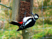
We woke the next day to bright sunshine on the surrounding mountains, a nosey sheep at our window and a great spotted woodpecker in our garden at Ty Maen! It was going to be a great day! Perfect weather for climbing a mountain or two. But not before we'd re-traced our steps to Dolbadarn Castle, to re-take the photos taken earlier in the week, to re-place the previously grey background with a bright blue one!

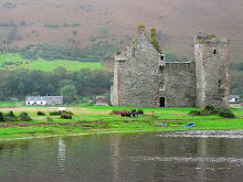
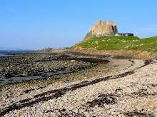
Dolbadarn Castle stands rather forlornly on it's rocky hillock some 80 feet above Llyn Padarn. It's strategic value is perhaps best recognised by reference to a map. Clearly, it's position at the tip of the lake allowed the garrison to blockade anyones movement through that part of the north, then as now a main link to the rest of Wales. The military worth of the spot was evidently recognised as early as the 6th century but surviving masonry dates no earlier than the 1200's. An impressive structure, both imposing and good at posing!

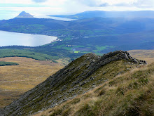
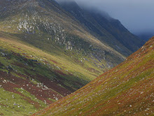
Glyder Fach (994m) was even more impressive, but also more challenging. The ascent began just a stone's throw away, at the end of the lane leading to Ty Maen. It started well, but very soon the footpath lost it's definition and disappeared altogether, making it difficult to trace the way forward. But at every step there was always a guaranteed jaw dropping view to compensate; views behind of Ty Maen getting ever smaller as it blended into the mountain side; views of the Snowdon Mountain Railway chugging it's way across the sharp ridge between mountain and sky, and views right down the Llanberis Pass, guarded by mountains, filled with lakes and leading to places unknown in the distance.

As the gradient increased, so too did the amount of times we stopped to gaze in awe at it! And the higher we climbed, so the mountain tantilisingly revealed a little more of it's secret picture. As the route got steeper the craggy scree gave way to huge rocky boulders, and the ascent grew more challenging. But our determination to get to the top also increased, encouraged all the way by the magnificent photo opportunities we were offered. As we climbed even higher the terrain changed again, to a broad grassy plateau stretching all the way to the summit, which was always just out of sight! We kept going for some considerable time, but on reaching the conclusion that we were probably still an hour off reaching the summit, we had to make the decision to start the descent. After all, we had a train to catch!

Our second mountain climb of the day was up the highest mountain in Wales (1085m) but it wasn't going to be as strenuous as the first. We'd planned to take the Snowdon Mountain Railway up to the (temporary) summit, and having had to pre-book our ticket we really didn't want to miss the train. I'd climbed the more strenuous route up Pyg track some 7 years previously, so this wasn't going to be a guilt trip! But it did seem we were destined not to reach summits that day. The new £8.3 million Visitor Centre being built at the top of Mount Snowdon was still under construction and would continue to be for another 2 years. All the building materials were being transported to the summit by the 8 trains in service, which meant a reduction in scheduled trips, as well as the route, by 50%. We knew in advance that our journey would be foreshortened, but the views even from part way up, were going to be well worth the compromise.

As our train left Llanberis station we began the steep incline up the first of the two amazing viaducts crossing Afon Hwch, passing a beautiful waterfall and ancient forest. Beyond the waterfall the train emerged into open, treeless countryside and we had our first glimpse of the sharp craggy peak of Snowdon. A quarter of the way up we crossed the passing loop at Hebron, site of a small ruined Chapel which held its last service in the 1950’s. Just as we approached the halfway point the train passed through a cutting that was hewn out by hand and blasted with dynamite in the winter of 1894. At the halfway point the train moved into the second loop in the track to take on water before continuing it's way up to Rocky Valley. This area is the termination point when high winds prevent the trains from reaching the Summit, neither of which was relevant to our trip!

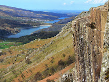
Beyond the halfway mark the black volcanic rock face of Clogwyn du’r Arddu came into sight, closely followed by the Station at Clogwyn, the termination point prior to the Summit opening. This was our prompt to get out of the train and check out the spectacular views - up through Pen-y-Pass, up the face of Glyder Fach which we'd climbed that morning, down the mountain below us to Ty Maen, our tiny cottage, along the Llanberis pass, across the slate mountains, over the twin lakes and way, way beyond.

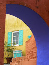
The next day was a mountain-free zone! We chose instead to drive to the unique and quirky town of Portmeirion, located on it's own private peninsula, perched on a tree-cladded hillside overlooking Whitesands Bay. Portmeirion is a private resort which was built by Sir Clough Williams-Ellis between 1925-1976. The architecture is primarily known as Italianate, with some buildings designed by the architect and others being rescued follies from other locations.

Portmeirion's colorful and flamboyant architecture and landscape offered a wealth of photo opportunities, and had it been empty of tourists, the photos taken would have been that much better! Having said that, it was a fascinating place and we enjoyed exploring all the nooks, crannies, follies and fantasies created by the architect. We also enjoyed a picnic with uninterrupted and unpopulated views over the breathtakingly beautiful wide sweeping sands of Whitesands Bay.

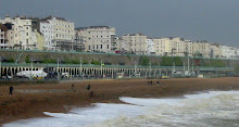
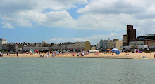
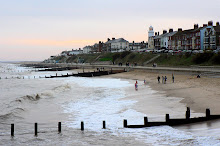
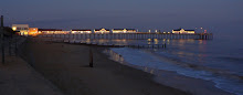
We continued our drive, hugging the west coastline of Wales along the north shores of Cardigan Bay, and past the imposing and spectacularly sited Harlech Castle, which seems to grow naturally from the rock on which it is perched! But our destination was Barmouth, a small but popular Victorian seaside town
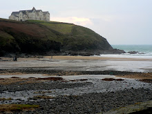
, closely backed by steep and jagged rocky crags, fronted by ash-blonde sands and bordered by the dramatic Mawddach estuary. Whilst (in our opinion) there were too many people around to make this a photogenic landscape, there was no denying that the quaint old town of Barmouth has been blessed with a dramatic, almost theatrical backdrop to it's pretty streets and beach-scape.

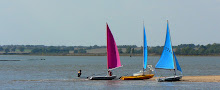
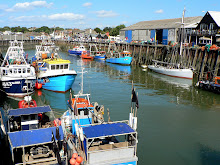
The imposing white 'Bath House Cafe' is also impressive, being stunningly situated on a stretch of clean pale sand, facing mauve mountains in the distance to one side, the blue of the ocean on the other and a pretty estuary with colorful boats and bridge in between. Oh, and it also got the thumbs up for having great cappuchino and superb subject matter on it's menu!

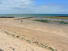
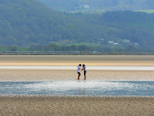
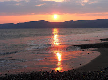
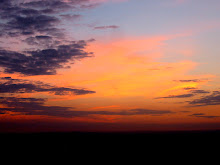
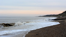
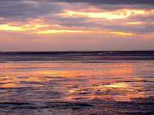
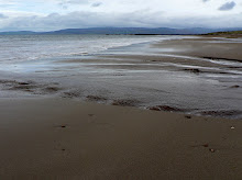
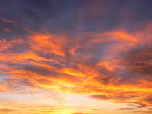
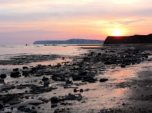
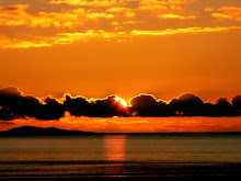
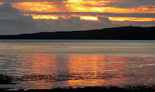
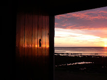
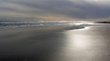
As if to round the day off perfectly we drove back along the coast, along the south Lleyn Peninsula, and found Porth Neigwl. We'd been looking on the map for a quiet stretch of coastline which would provide us with a natural landscape, an interesting beach, a pretty landscape, a peaceful walk, and, just maybe, a perfect sunset. The remote beach at Porth Neigwl ticked all the boxes. We walked for a couple of hours on a deserted stretch of sand, sprinkled with stones and shells, edged by dunes and framed at the far end with mountains. There was no adjoining town, no buildings, no people, no noise, just nature - and the most amazing coral pink sunset casting it's reflection on the sea, before disappearing behind the mountain. What a special place.

During our holiday in North Wales we'd been around valleys, across islands, up mountains, inside mountains, along beaches, in trains and through towns. What we hadn't done was a walk in the Welsh countryside, so that's what we decided on for our last day.

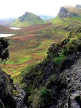
Our first walk was called 'An Alpine Journey Above the Llugwy', and it encircled Capel Curig. At the heart of the Snowdonia National Park, this rugged mountain village is the mecca for climbing and walking in Snowdonia. Ringed by Moel Siabod, The Glyders and Carnedds (mountains), Capel Curig stands before the majestic view of the Snowdon Horseshoe. The Afon Llugwy (river tributary) flows through the village with beautiful falls at Pont Cyfyng, and the twin lakes Llynnau Mymbyr fill the valley, close to Plas y Brenin (The National Centre for Mountain Activities). Quite impressive for such a little village! And there's more. In the 1950's the Pen y Gwryd Inn became a centre for planning Alpine and Himalayan expeditions. Here Lord Hunt and his team, who in 1953 were the first to climb Everest, met to make the final preparations before departing for Nepal. The Climbers' Bar has a wood ceiling that has been autographed by many world famous climbers, including the summit pair, Sir Edmund Hillary and Tenzing Norgay.

Our short walk might not have been on the same scale as Everest, but in 4 miles it rounded the valley, taking in spectacular views of the wide sweep of mountains that surround the village and the Llugwy Valley. We climbed up hills, over crags, down dales, across pastures and through bogs (that was me!); jumped streams, crossed rivers, skirted woods and walked along the shores of the lake, before returning to the start point, the cafe, Joe Brown's climbing gear shop and our car, all of which we were glad to see for very different reasons!

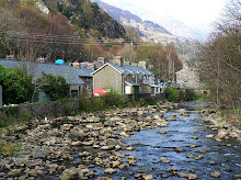
Imagine a lovely unspoilt village in the heart of the Welsh countryside, it's picturesque bridge crossing the River Colwyn just upstream of it's confluence with the River Glaslyn. Charming stone and slate cottages line narrow winding roads through the village, and mountains surround it on all sides. This is Beddgelert, site of our second walk on our last day in North Wales.

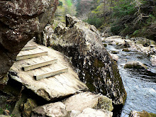
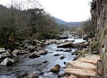
Our walk closely hugged the twists and turns of the River Glaslyn as it tumbled over rocks, rushed around boulders and cascaded down the uneven bed of the Aberlaslyn Pass. That made it all the prettier. However the footpath was just as varied as the river-path, and that made it all the trickier! At one point the path consisted of a narrow ledge, 3 feet above the river, about 12 inches wide, but with 6 of those under the overhang of the rock above. But as the path got trickier the riverscape got prettier, the tree lined banks got thicker and so we continued along the route, keen to see what lay ahead. It was another tricky bit! This time a leap was required, across some wet boulders and onto a wooden path leading us upwards and out of trouble. I say 'we' but you'll understand I mean 'me', as I appear to be the one without any sense of balance, but with an all too vivid sense of fear. But without wishing to dwell on the negatives, this was indeed a very pretty riverside walk, as I hope the photos confirm.

But just as our walk wasn't complete without visiting Beddgelert's namesake, neither can we leave this posting without mentioning the tale of Llewelyn and his legendary hound, Gelert. The story, as written on the tombstone reads: "In the 13th century Llewelyn, prince of North Wales, had a palace at Beddgelert. One day he went hunting without Gelert, "The Faithful Hound", who was unaccountably absent. On Llewelyn's return the truant, stained and smeared with blood, joyfully sprang to meet his master. The prince alarmed hastened to find his son, and saw the infant's cot empty, the bedclothes and floor covered with blood. The frantic father plunged his sword into the hound's side, thinking it had killed his heir. The dog's dying yell was answered by a child's cry. Llewelyn searched and discovered his boy unharmed, but near by lay the body of a mighty wolf which Gelert had slain. The prince filled with remorse is said never to have smiled again. He buried Gelert here". It is now widely accepted that the village of Beddgelert has taken its name from an early saint named Kilart or Celert, rather than from the dog. The existence of the "grave" mound is ascribed to the activities of a late eighteenth-century landlord of the Goat Hotel in Beddgelert, David Pritchard, who connected the legend to the village in order to encourage tourism and to boost his own takings.

Whether you believe in the authenticity of the legend or not, the fact that Beddgelert translates into 'Gelert's Grave' is enough to keep the myth and the tourist coffers alive and healthy, and anyway a salutary but cautionary tale with a moral is always a good one to tell at parties!

I might even spread a rumour myself - about North Wales having more than it's fair share of beautiful scenery in the UK. The moral to this story is check it out for yourself, you'll be pleased you did!

Monday 18 May 2009

Dorset

We decided to take an impromptu mini break on the south coast, and Dorset was the number one choice. Having wanted to go to Lulworth Cove, and given that it's located on the Jurassic Coast, and forms part of the Natural World Heritage Coastline, it seemed an ideal choice. Clearly cameras would be going into suitcases, and into action! A quick Google session secured a pretty B&B in the conveniently positioned and quiet village of Coombe Keynes just north of the coast, and we were off.

Lulworth Cove is a natural horseshoe-shaped harbour cut out of the coastline, as if by a giant pastry cutter. It's one of the finest examples of such a landform in the world, and is inevitably a prime attraction for the area, especially for geology enthusiasts and photographers! But its just one of a number of rare and fascinating natural rock formations recording 185 millions years of the Earth's history in a 95 mile stretch of truly stunning coastline from East Devon to Dorset. World Heritage status was achieved because of the site's unique geological ‘walk through time' spanning the Triassic, Jurassic and Cretaceous periods. Overwhelming - but I just wanted to find one small fossil to take home with me ... .

Our first exploration of the coast was along the South West Coast Path, a white chalky trail leading west from Lulworth Cove. This must be one of the most tourist-trod routes in the country, and we (reluctantly) joined the trail of people who were also keen to see what this coast had to offer. Despite not having the place to ourselves, and even knowing what attractions lay ahead (as we'd researched the place), we weren't prepared for the stunning panoramas.

The first geological gem on this route is a 'blow hole' where the sea has exploited a weak spot in the rocks and this has led to erosion. It's also a superb illustration of folding strata, formed by the action of the sea on the soft Portland and Purbeck limestone. 'Stair Hole' looks a bit like a squashed crinkled fan, but this type of rock formation is more aptly known as 'Lulworth Crumple'. It's a relatively new cove, as geological structures go, and in just a few 'short' hundred thousand years it's predicted to be just as large and spectacular as Lulworth Cove! Not stopping around to see this, we continued along the undulating but not unchallenging chalky path (which I re-named the 'scar on the landscape', after realising it could be seen from miles away), until we reached the next stretch of Jurassic gems, from St Oswald's Bay to Man 'O War Bay.

Okay, so the sky was a piercing blue, the sun was glowing golden, the sea azure, the sand pale cream and the cliffs dazzling white, but the sweeping, sculptured curves of the coastline around St Oswald's and Man o' War Bays are just so beautiful. Looking along this shapely, flawless coastline on such a perfect summer's day was a visual feast for the eyes (and the camera!). As we neared the rocky headland at the far end of Man o' War Bay we realised that what were were looking at was in fact the back of Durdle Door, the most known and photographed natural limestone arch in the country.

On reaching the spit of land jutting out into the sea we turned across it down the narrow path on the 'saddle', which soon divided left and right, giving us two choices. To the left there was a long, steep and narrow set of steps leading down to the perfect little 'Man o' War Bay, far below. To the right a winding, less direct trail of steps down to Durdle Door. We chose the latter, simply because there was is no access from one to the other at beach level, and Durdle Door was definitely not the option to be missed!

Durdle Door and Man o' War are what remain after millennia of sea erosion of the cliffs near Lulworth Cove. This spit of land is made of limestone, and the sea has worn away both the limestone and clay back to the chalk cliffs. From this vantage point there is a panoramic view over the surrounding coastline all the way to Portland Bill and Weymouth in the west and back to Lulworth Cove in the east. Phew, quite a view!

Once at 'sand' level we took a long walk along the narrow shingle strip of beach towards the next headland, Bat's head. The views along (and through) Durdle Door and the Bay are undeniably beautiful, but as we headed towards Bat's head, yet another geo-gem came into view. Right at the tip of the headland the sea has mined a tunnel through the rock leaving 'Star Hole', a small 'blow hole' which is navigable and therefore a popular route for all local canoe and dingy clubs who take advantage of this splendid stretch of coast (and no doubt of the tourists' holiday money as well!). Star hole is said to also house bats, but we didn't see any evidence of these. Neither did we see any evidence of the naturists that apparently have use of this remote section of the bay, in fact with the exception of 1 or 2 people this end of the beach was deserted. After more than half an hour struggling to trudge through the deep layers of sinking shingle, our legs (and ears) were relieved to get back onto terra firma! In retrospect, it can't be the most comfortable of surfaces for people to lie on, clothed or otherwise ... .

At this point we turned eastwards back towards Lulworth cove, as I was keen to explore the famous 'Fossil Forest', just a mile or so beyond the cove. This was surely where I'd pick up a fossil to take home ... .

After a quick stop at the local Lulworth watering hole, we took the circular route (!) around Lulworth cove, before climbing up and over the western headland onto Bindon Hill, following the path to the Fossil Forest, on the edge of the Bindon Army Firing Range. The 'forest' location was not what I envisaged! It's perched on a precipitous ledge on the cliff face overlooking the sea, accessed by a steep 50ft climb down the said cliff face (albeit on a purpose-built steel structure). The 'remains' of the forest were also not what I expected, but were fascinating nevertheless. What remains are the growths, or moulds of late Jurassic or early Cretaceous coniferous trees that have formed around the tree stumps from about 135 million years ago, in the underlying 'Dirt Beds'. Higher up the ledge above the 'trees' we saw stromatolites and thrombolites (see photo), layered structures formed in shallow water by the trapping, binding and cementation of sedimentary grains by micro-organisms such as algae. Clearly geology isn't my field, so I'll quit while I'm ahead. Needless to say, it was an intriguing place, good for the imagination, excellent for photographs, but hopeless for finding fossils small enough to take home!

Having attempted to learn the basics of geology, the next day we turned to the history of the area, and more specifically the 'forgotten village' of Tyneham, steeped in medieval history, buried deep in the Tyneham Valley, but positioned in the middle of the MOD Firing Range!

Tyneham went under military occupation 6 days before Christmas 1943 for the training of American and British tank crews. The promise to return Tyneham to it's inhabitants was never kept, and the area is still used for firing live shells. The village and range walks on this section of the Dorset Coastal Path are regularly open to the public. But Tyneham is now a ghost village, the domestic buildings being in ruins. An eerie and poignant visit to this once pretty village, where visitors were reminded to: "Please treat the church and houses with care; we have given up our homes where many of us lived for generations to help win the war and to keep men free. We shall return one day and thank you for treating the village kindly." They're still waiting.

That evening we had dinner at The Ship Inn at Wool, a small village at the foot of the Purbeck Hills, which boasts a 14th century manor house, and whose claim to fame is being the location of Tess'
honeymoon in Thomas Hardy's Tess of the D'Urbervilles. I remember it for different reasons. On leaving The Ship Inn we found that the sky was ablaze with a full-on orange and pink Dorset sunset! Faster than a speeding bullet across the Firing Range, we got into the car and shot up the Purbeck Hills, taking S-bends with speed and precision that would have impressed Colin McRae, past the MOD firing range without getting shot, and up to the vantage point, cameras poised! We missed the best of the sunset, but not for the want of trying - and it was great fun!

On our last day we drove eastwards to Kimmeridge Bay, home to The Purbeck Marine Wildlife Reserve and to a geological feast! Characterised by it's dark, fossil rich shale beds, Kimmeridge Bay lies between the white chalk cliffs of Tyneham and Lulworth to the west and the pale grey limestones of the Isle of Purbeck to the east. Kimmeridge Bay itself is part of the privately owned Smedmore Estate and is dominated by Clavell's Tower, a one-time summerhouse and coastguard lookout, built in 1831. We have lasting memories of the Tower, but more specifically of a couple of hardy and quite eccentric 'charity trekkers with a heart.' Dressed in khaki from hat to boots, with tall white banners held aloft, map cases and cameras slung around necks, and a look of determination on their faces, they proudly told us they were walking the South West Coast Path in aid of the Heart Foundation. Good on them!

The final stop of our short but full mini-break was to Lulworth Castle,
built in the early 17th Century as a hunting lodge, but turned into a country house at the heart of a large estate. Thomas Howard, 3rd Lord Bindon, built the Castle in order to entertain hunting parties for the King and Court. The Howards owned it until 1641 when it was purchased by Humphrey Weld, the direct ancestor of the present owners. The exterior of the Castle changed little over the years but the interior evolved in line with changing fashions until it was gutted by a disastrous fire in 1929. Restoration work began on the ruin by the Department of the Environment and was followed through to completion in 1998 by English Heritage.

What captured our attention more than the restored and resurrected heritage of the landed gentry, was the jousting tournament in the grounds of the castle estate. A colourful, humourous and lively display with plenty of activity, horseplay, jestering and audience participation! And in 'time honoured tradition' the evil dastardly black knight fought a dirty fight, lost everything and was booed out of the arena, whilst the honourable worthy knight won battle and fair maiden and rode off with her into the sunset on his trusty charger.

So a happy ending for all (except the baddie), and a happy ending to our Dorset break too! (Except, of course, that in 'time honoured holiday tradition' I didn't fulfil my hopes of finding a fossil to take home (no fossil in Dorset, no dinosaur footprint on the Isle of Wight, no puffins on Farne, no otters on Skye, no red squirrels on Arran - see previous postings!).


Friday 15 May 2009

Cornwall

The concept of spending Christmas away was a new one to me, and one I was curious rather than convinced about. However, Christmas in Cornwall had a certain appeal that couldn't be ignored, especially as we were not intending to reproduce the festivities in a different place, rather the idea was to ignore the commercial trappings of Christmas and to do something completely different, and in my case, break the habits of a lifetime!

With the car boot loaded up to the hilt with warm walking clothes, camera equipment, mince pies and some fairy lights (the latter being my contribution and the only concession to our Christmas-free break) we set off to Church Cove, on The Lizard peninsula. It was quite late by the time we arrived in Cornwall, and as the skies blackened and the lanes got ever narrower we slowed our speed to carefully negotiate the gradually sloping lanes into Church Cove. Even in the pitch dark this place looked idyllic, and after a few more twists and turns along the lane our picture perfect thatched cottage came into view in one jaw dropping moment! It was then I knew that Christmas here was the right decision!

The next day that realisation was re-confirmed when I looked out of the window and saw that our cottage was at the end of the lane, perched at the top of the gentle slope leading down to the cove. Church cove is a picturesque inlet on a rocky coastline, sheltered, understated and small. It used to house the lifeboat, but the original boathouse has now been converted to a holiday cottage and sits amongst a handful of other small, simple and sympathetically renovated buildings such as The Winch House and The Round House, all of which are centred around the steep narrow slipway sprinkled with colourful boats.

Our first day and first walk began with a stroll down to the cove and continued along the winding cliff top path around the craggy coastline from Church Cove, past dramatic views across Housel Bay, Bumble Rock, Polbream and Polpeor Coves to Lizard Point, stopping along the way for copious photographs, misty views of the Lizard Lighthouse and to stroke the shy, slightly scruffy but very cute Cornish ponies. Through the mist the Lighthouse proved it's worth, and workability, by sounding the foghorn (deafeningly) just as we rounded the Point, and before we turned away from the coast and headed off to explore the village of Lizard.

The remainder of the day was spent in one of the most spectacular coves in Britain, and one that remains very special to me. I'd seen remarkable photos of this place before and been completely blown away by it's beauty and mystical quality. To see it for real was both moving and memorable. Kynance Cove is an inlet on the Lizard peninsula known for it's rugged cliffs, white sand and turquoise water. But even more significantly, it boasts islands of multi-coloured serpentine rock with stacks and arches hidden amongst the towering cliffs. An outstanding feature is the fact that at high tide a sandy beach which faces the water on two sides and a small island, which becomes a tidal island, are cut off and thus inaccessible. If you're fortunate enough to be there when the sun goes down behind this impossibly beautiful place, the image will be imprinted on your memory, as it was mine.

That evening in the cottage we exchanged our gifts, a fitting end to a magical first day, and to Christmas Eve. Continuing our non-traditional non-festive theme (but excluding the Christmas hat worn by my partner which, I may say, drew admiring and amused glances from the locals), we spent the 25th exploring the south west coastline from Mousehole to Sennen Cove. Whilst everyone else in Cornwall was knee deep in tinsel, turkey, tree needles and TV repeats, we walked across footprint-less beaches, around deserted harbours, along abandoned cliff paths, and car-less roads until they ran out at Land's End.

Two particular memories of our Christmas Day remain with me. The first was a place we stumbled on by accident after taking a wrong turn (guess who was map-reading). Lamorna is a small cove on the Penwith peninsula, a quiet fishing village comprising a small cluster of houses congregated around a natural harbour. Apart from the obvious beauty of this place it's claim to fame was becoming popular landscape material for many of the painters of the Newlyn School at the end of the 19th century. I was unaware of this history at the time we visited, but like the artists, was drawn to the remote, rocky and rugged landscape of this tiny 'mistake' in our itinerary. The second memory was of 'Telegraph Beach' (as I re-named it), or Porthcurno.

Actually, my memory of this place has been kept alive by the BBC TV 'Coast' Series, which featured Porthcurno in one of it's programmes, before we went to Cornwall. So unlike the accidental visit to Lamorna, Porthcurno was researched, planned and very much looked forward to! Thanks to the Beeb and Neil Oliver I had learned that in 1870, Porthcurno made history under the beach. This secluded bay was where Britain was wired to the world, by a network of fourteen cables stretched from under the beach around the globe. Significantly and for the first time in history, telegraphy made rapid communication possible between Britain and her distant colonies. But history was also made above this beach some years later. In 1932 the open air Minack Theatre opened it's 'hypothetical doors' to performances under the stars, perched on top of Porthcurno cliffs with Oscar winning views across the bay. Hard to believe that such a quiet and unassuming bay harbours such significant and historical events in it's landscape.

Lands End deserves a mention here, due to the significance of its geographical location. We stood at this remote and most westerly point of our island acknowledging the beauty of the landscape but thinking how much better it would have been without the inappropriate commercial visitor attractions - the place would sell itself without the 'help' of humans. So we moved swiftly on to Sennen Cove, a large sweeping bay that 'knocked Land's End into a cocked hat'! Sennen Cove (but more like a bay) is the home of surfers, the RNLI, Bilbo the first canine lifeguard - and photographers! With such a stunning wide landscape, lifeboat station, colourful fishing boats and their associated tackle, it had more than enough material to keep camera shutters clicking ... until it was time to get back to the cottage for some non-traditional Cantonese Christmas Fayre with chopsticks and crackers - a very happy Cornish Christmas!

Conforming (albeit coincidentally) with true Boxing Day traditions, we decided to take a long walk. From Kynance Cove to Mullion Cove and back. It was a dry day but cold fresh winds had whipped the waves up, transforming the previously tranquil scene at Kynance Cove into a cauldron of churning, swelling sea, a frenzy of foam, spume and spray. Finally dragging ourselves away from the spectacle, we walked along the craggy cliff tops with cove to cove views over perilous crumbling cliffs down to the rocky shores below, most of which were stunning but inaccessible.

We eventually reached a National Trust sign at Predannack which informed us that Mullion Cove was another 2 miles on. Having walked 2 miles in as many hours, and with only 2 left in daylight, we decided to be sensible, hedge our bets and head back. This gave us time to mingle with some very shaggy and photogenic ponies before setting off to look for a suitable picnic spot, and we found just the place (centre left on photo). And so, perched on the edge of a deep cut in the cliffs, overlooking the rocky shore below and sheltered from the wind by what remained of a walled pen of some sort, we enjoyed our Cornish picnic of scones and clotted cream!

On arriving back at Kynance Cove the tide was out, revealing the secrets of the 2-sided sandy beach in all it's glory. Like children in a sweet shop, we reveled in the new choices open to us, scouring the beach with our eyes, taking in the patterns and pools created in the sand by the sea as it rushed in and retreated just as quickly, watching the waves as they swirled around the rocks engulfing and transforming them into islands, and the matt sand canvas being given a new coat of gloss with one sweep of the sea. All we could do was try to capture as much of this mystical landscape as was possible before the tide took it away from us. Oh, and did I mention the salmon pink sunset that backlit Kynance cove as the tide performed it's magic on this very special stage.

With the events of each day exceeding our expectations, we had high hopes for another lovely walk and more stunning vistas. This time heading north from Church Cove we walked along the cliff tops towards the picture postcard fishing village of Cadgwith. Even though the sun didn't show it's face, an intensely happy hour or two was spent beachcombing and capturing shots in this delightful little bay amongst the colourful rows of fishing boats, and the selection of ropes, buoys, flags, sails, lobster pots and nets that adorned it. Photos of boats across their bow, under the boom, behind buoys, through baskets; with sea in the background, with brightly coloured fenders in the foreground; from below the stern, up the sail, through coils of rope ... so much variety and so little battery! But I liked Cadgwith! I also liked the Cornish pasty we had in the 'Cadgwith Cove' Inn before we moved on ... .

The second half of our day involved a short drive to Poldhu Cove further westwards around the coast. Famous as the place from which the first Trans-Atlantic radio signal was sent in 1901, but memorable for me because of it's natural beauty. Poldhu is a popular sandy beach located in a pretty position filling a deep inlet, with hills to each side and fields behind. The beach is stunning and entirely unspoilt; the boundary between fields and sand have been blurred by the tall reeds, grass and a small stream which have overspilled onto the beach; the edges of the wide expanse of cream, apricot and taupe sand are studded with large flat stones in every tone of grey and beige. Add to this image shimmering fresh water trails swirling their way around the stones and across the sand, creating patterns on the surface as they trickle their way to the sea. Another remote, quiet and special place.

We made one final stop for the day. Porthleven harbour is the most southerly port in England. It is also unusual because the mouth of the harbour faces directly to the south west and some of the strongest gales. This is because Porthleven harbour was developed in the early 19th century as a safe harbour for ships caught in stormy seas. Soon after the initial construction the inner harbour was created to give further protection for boats from the fiercest storms. Sadly in the 1970s this additional protection was not sufficient to prevent a parked police car and it's two occupants from being swept off the harbour wall and into a stormy sea.

These days Porthleven harbour is a thriving tourist spot where visitors can buy Cornish pasties or cream teas from small, colourful cafes; or local artwork and crafts from unique chic galleries, freshly caught fish from a selection of smart restaurants, or liquid refreshment from a variety of Inns, most notably the ancient Ship Inn (which is also said to offer a ghost too!). And around the headland next to the harbour, but separated by a granite pier, is Porthleven's beach, stunning in the sun and spectacular in a storm (a return visit later in the week gave us a a small insight into the storms around this coastline!). Unfortunately the first rain of our holiday combined with December's short daylight hours meant the camera stayed in it's case here. But it had been a long day and we'd covered a lot of Cornish ground, 'on foot' and 'in car'. Now it was time for sleep, 'in bed'.

Most nights we were lulled to sleep with the regular flashing pulse of the Lizard Lighthouse; occasionally it was accompanied by the regular deep and penetrating warning signal of the foghorn; but on this particular morning we were woken by a magnificent sunrise, it's bright pink and mauve light flooding our cottage and everything in it! Despite getting up, out and across to Lizard Point at breakneck speed, we missed the best of it, but it gave us a good early start for the day ahead.

Our plan was to drive across the Cornish peninsula to St Ives, with expectations of a pretty bay, a perfect sandy beach, a picturesque backdrop of pastel cottages, colourful boats in the harbour and a late breakfast in a bistro! All of the above was achieved and more. The town is an artist's haven, full of studios, galleries and shops displaying works of art that have benefited from the much acclaimed 'quality of light' that St Ives is so famous for. It is no accident that this is one of the few places in the Britain to have it's own School of Painting. In the late 19th century artists such as Whistler were drawn to the place by it's purity of light and warmth of climate. Not unlike Whistler, we were drawn to the photo opportunities, but had to compromise on the warmth of climate!

The next morning (29th December and the day of our departure) the uncompromising climate worked in our favour. We awoke to unexpectedly wild and stormy gale force winds, which, of course, meant only one thing - a delay to our homeward journey until we had captured the stormy seas on camera! At Lizard Point we battled to stay upright as we got out of the car, and again as we tried to get our coats on without them acting as billowing sails ready to whip us off our feet. We were then buffeted by the strong gusts as we struggled to get down the slipway. Our attempts to get closer to the raging seas whilst at the same time protecting our lenses from the violent spray, were met with resistance at every step, but after half an hour we returned to the car wet, exhausted, exhilarated and in possession of some hard-earned stormy pictures! As if to reward us for our bravery, Britain's 'Most Southerly Cafe' was finally open, so we had one last but very special Cornish Cream Tea before heading off home.

Would I spend Christmas away from home again? Oh, I think so, once in while. I do love the traditional aspects and values of Christmas but surely life is also about new experiences, being spontaneous, broadening horizons and breaking the habits of a lifetime! A choice between Christmas 'commercialism' vs Cornwall at Christmas? No contest!

Wednesday 13 May 2009

Suffolk

A weekend trip to Suffolk revealed more unexpected gems on the East Anglian coastline. Our first stop was in Woodbridge, an ancient and pretty market town nestling in a curve of the River Deben. The area is dominated by a stunning white 12th century Tidal mill which sits at the confluence of river estuary and town, enticing you to meander further downstream. This is further encouraged by a boarded walkway along the quayside which threads it's way around the winding river, past moorings and jetties, and boats of very size, colour and shape.

Our next stop was to the much acclaimed pretty coastal town of Aldeburgh, known by music lovers and poets worldwide. The famous annual Aldeburgh Festival was introduced by Benjamin Britten, who lived there until 1957. Every summer this quiet Georgian town transforms into a vibrant arts centre as hundreds of visitors flock to concerts in the old disused malthouses, now sympathetically restored and renovated to house musicians. When we visited Aldeburgh out of season we saw only a handful of visitors, wandering along the shingle shore, watching the fishing boats and admiring the unique 4-metre high steep scallop sculpture on the beach, a tribute to Britten, whose inspiration is said to have come from the sea.

Further up the coast is another well known historical Suffolk town, or rather, what remains of one. Hard to believe that Dunwich was once a thriving city with a population of 3,000, an important boat building industry and harbour, and an impressive fleet of royal ships. It's position on the coast led Dunwich to prosperity, but also to it's downfall, for the cliffs were made of sand and gravel and were subject to constant ‘soil creep,’ and cliff erosion.

On the 14th January 1328 disaster struck. A wind of hurricane proportions drove the sea against the spit of land called the Kings Holme, shifting the shingle and effectively blocking the entrance to Dunwich harbour. Despite the valiant efforts of it's inhabitants the supremacy of the port was lost. Dunwich’s inhabitants worked hard to clear the harbour entrance but this was a battle that could not be won. The sea continued to make incursions, and during the fourteenth century it was recorded that 400 houses, 2 churches, as well as shops and windmills, succumbed to the tempest. Tales of a lost city under the waves are indeed true, although the ravages of the sea left little intact. Despite this divers have been exploring the murky waters off Dunwich for many years and certain items have been found. We listened for the ghostly tolling of church bells, but heard only the sound of the shingle as it was pushed and pulled back and forth by the tide.

Southwold, however, is a thriving, charming, well groomed and quintessentially English seaside resort on the Suffolk Heritage Coast, complete with working lighthouse, smart pier and colour co-ordinated beach huts. A placed loved by artists, photographers and authors. For just as Aldeburgh is linked with the Arts, so too is Southwold, but with all things literary rather than music. In November every year this genteel town buzzes with words, from book lovers, authors and speakers at the 'Way with Words' Southwold Literary Festival. There was not a book to be seen nor a speaker to be heard when we visited, just a very beautiful sunset over a very pretty pier which needed no words, just photographs!

Sunday 10 May 2009

Norfolk

Living in the middle of the UK, it's easy to feel land-locked, but thankfully the East Anglian coastline is only an hour or two away. More significantly it offers a wealth of stunning scenery, sweeping white sandy beaches, huge dramatic skies, pretty villages and historic market towns. If that hasn't convinced you, large parts of the area are also designated 'Areas of Outstanding Natural Beauty' (ANOB), 'North Norfolk Heritage Coast', Sites of Special Scientific Interest (SSSI) and RSPB nature reserves, and with an extensive Coast Path conveniently intertwined around these sights and sites, it comes highly recommended, if you, like me, like all things natural.

One of the few beaches in East Anglia that faces West is Snettisham, overlooking The Wash. It's a unique and special place, quiet and off the beaten track, offering a retreat, somewhere for solace or rejuvenation, or to catch your breath in a busy world. It's also somewhere to witness one of nature's most awesome sights and sounds - the dawn flight of thousands of pink-footed geese gaggling noisily as they fly from the mudflats after being pushed off their feeding grounds by the tide, over Snettisham beach to the roost banks and islands in the RSPB nature reserve.

Snettisham is one of Norfolk's best kept secrets, home to thousands of species of water birds but only visited by those determined enough to be there - people with scopes, cameras and walking boots mainly - as there's no vehicle access to the beach. The photo opportunities are endless, from the dawn flights against a salmon pink sky, across the sculptured swirling patterns of the mudflats, to the long photogenic line of single-storey bungalows perched on an elevated ridge at the top of the beach, overlooking the sea to the front and the RSPB lake to the rear! This place is hard to leave behind ... .

But there is more to see! Continuing towards the north Norfolk coast you'll come across the sleepy little village of Holme Next the Sea, but don't be fooled into thinking that's all there is to this place! This is where you can pick up the North Norfolk Coast Path and follow it eastwards as it hugs the coastline for 30 or so miles all the way to Cromer! What you will see is mile upon mile of wide white sandy tidelines, grassy dunes and spits, and behind it an extensive area rich in salt marshes, creeks and dunes, all accessible on foot. 'Must see' places en route include Wells next the Sea (which is actually quite a long walk from the sea!) and Blakeney Point (a nature reserve at the end of a long sand spit, accessed the easy way by boat, or the painful way, on foot ...). Guess which we did!

We recently re-visited Blakeney with the sole intention of walking the whole length of the spit to the Point, to see the seals. What I failed to establish before we embarked on this venture was the length of the said sandspit! Driven by a need to see the seals and to achieve my objective, we set off along the beach towards infinity, or so it seemed. An hour later the horizon still looked the same. Another half hour on and we were exposed to the cold easterly winds which began to whip up the soft sand making it feel more like a desert storm than a walk along the coast.

Two hours on we saw our first sprinkling of seals and suddenly the long walk was worthwhile. Determined to have pictorial evidence of the focal point to our epic trek, we took photos of these cute but perplexed creatures before turning tail to retrace what was left of our footprints - only by now the temperature had plummeted almost as much as the force of the north east winds had intensified! Worse still, the sea had reclaimed the sandy shoreline leaving us to scrunch our way noisily across mile after mile of shingle towards yet another horizon that didn't seem to ever get any closer. But it was only 6 miles in total, and we'd achieved our objective of walking to the Point, and we'd seen the Blakeney seals - result!

We'd decided to end a previous day trip to Norfolk visit by seeing what Wells next the Sea was like, to sit by the harbour, watch the boats, have fish 'n chips, see the famous beach huts and of course, the sea ... but we hadn't anticipated a long walk too. Wells isn't so much 'next the sea' as 'nowhere near the sea'. As a result of silting in the harbour the sea is now a mile away from the town. But some time later we found it, after following families with buckets and spades, but as soon as we reached the long line of unique, brightly coloured, much-photographed beach huts ... my camera battery died! Another visit to 'Wells Not Next the Sea' is called for ... .

Following the Norfolk coastline clockwise past the seaside resorts of Cromer and beyond, we found another stunning example of Norfolk's unspoilt natural beaches. Sea Palling is tucked away, down a path, through a field and behind a screen of sand dunes! Once through the dunes the view on the other side is of a pale golden sandy beach stretching way into the distance, protected by nine off-shore reefs standing in the sea as if on guard. Erosion is a very real problem on this part of the coast, and the threat of flooding high. Perhaps nowhere more so than Happisburgh, which was our next stop.

My first thoughts when I stepped on the beach at Happisburgh was that it is anything but a 'Happi' place! (Actually this place is pronounced 'Hazeborough' but it looked 'unhappy' rather than 'hazy' so I'll stick with my original if incorrect pronunciation for now!). What made is less than 'happi' for me was the devastation caused to cliff top houses by erosion - the sea is doing it's best to reclaim the land, the beach, cliffs and anything that happens to be on it at the time. The evidence is strewn all around and is sad to see, but it's also a reminder of that such is the power of nature that it can't be challenged with any real success, and maybe we shouldn't even try.


Isle of Arran

Known as ‘Scotland in Miniature’, The Isle of Arran is said to be a condensed version of the best that Scotland has to offer, in terms of geology, landscape and amenities. It is also the seventh largest Scottish island nestled in the Firth of Clyde between Ayrshire and Kintyre. But we chose Arran as the destination for our Scottish Isle holiday primarily because it's the closest island to the mainland and therefore not too difficult to access without our car, as we were flying to Glasgow. So after a 9.5 hour journey by taxi, plane, train and ferry, we arrived, tired but eagerly anticipating the week. Our initial impressions of Arran had been formed by the magnificent mountains that become steadily more impressive as the ferry approached the island. Our second impressions were of the quietly bustling harbour and seafront at Brodick, the largest settlement on Arran, where we were to be based for the week. Now it was time to expand on those impressions with exciting experiences ...

The next morning we woke to light rain but, true to the vagaries of Scottish island weather, this was replaced with bright sunshine by the time our walking boots were on! Having consulted our 'Arran book of walks', we decided on the 6 mile round trip to Lamlash, further down the coast. The route wound its way up the lane behind our B&B, through woodland and forest areas adorned with bracken, heather and fungi in their autumn colours. A picnic 'with a view' en route kept energy levels going.

We approached Lamlash against the stunning backdrop of Holy Island (home to a Buddhist retreat), and, heading straight for the beach we put cameras into action. In between shots we beachcombed our way across the wide sweeping bay. But it wasn't long before we drifted in to the 'Drift Inn', conveniently situated on the beach, complete with commanding views over Holy Island. After bowls of hot lentil soup and warm baguettes, we turned back to Brodick, where we were treated to our first Arran sunset.

On the second day we discovered that the west coast of Arran is much less developed than the east, and the largest settlement is Blackwaterfoot, overlooking Drumadoon Bay. But everything is relative; Blackwaterfoot has a population of just 4500, and we probably saw around 10 of them! It also has a beach to die for, but please, not before taking photographic advantage of the amazing beach landscape! A couple of idyllic hours were spent on Blackwaterfoot beach with only seals, shells, seaweed, sand and rocks for company. It still rates as one of my favourite beaches in the UK, let alone Arran.

A hearty 'full Scottish' breakfast was called for on our third day, as we planned to climb up to Goatfell peak, a challenge taken up by many, and often the sole reason for visitors to the island. As forecast by the Beeb the sun was shining in a bright blue sky thereby removing all legitimate excuses not to attempt the 2886 ft ascent and 10.5 mile round trek. Confidently setting off at 10.00 am we agreed that getting to the 'treeline' would be a respectable milestone to reach, provisionally.

Once this had been achieved we pursued the long hard trail upwards across rocky outcrops, along a seemingly never-ending path of boulders rising into the distance for mile upon mile. We met a handful of walkers along the way, plus some French fashion victims, inappropriately dressed, out for a pose. We even posed ourselves, for a 'we did this together' photo, thanks to a fellow walker.

But as the final ascent came into view, so too did the realisation of what that entailed - some rock clambering! For me this meant serious doubt that I would reach the summit. Even more worryingly, would I be able to get down in an upright position! With patient reassurances and an ever-outstretched helping hand, I clambered up the steep uneven boulders and reached the summit, relieved, exhausted but exhilarated.

Panoramic views over Arran, Western Scotland, Northern Ireland, the Mull of Kintyre and the Western Isles surrounded us. The photo-opportunities were endless, however our time at the summit was cut short by me, due to nervous tension and the need to prove to myself that I could get back down the mountain in one piece! Clearly this was achieved, with the same helping hand that guided me up, and soon the worst stretch was behind us. However, the long slow seemingly endless descent down the winding rocky path tested our calves and knees to their limit! Back in Brodick we fell into the nearest eating house to recover, replenish and recognise our huge achievement. Later that evening, in the comfort of our B&B we re-traced our climb digitally on the Mac, and without further pain!

The following morning we awoke to a rainbow arching over Goatfell peak! Light showers once again quickly gave way to sun, and we were soon hot-footing it to Brodick Castle, dramatically situated on a shelf about the north side of Brodick Bay and under the shadow of Goatfell, which rises behind it. Brodick Castle can best be described as a strategically important defensive fortification from the 1200's to the 1600's with an 1800's stately home wrapped around it! The castle is set in 10 square miles of Brodick Country Park, maintained by the National Trust for Scotland and unique in being the only island Country Park in Britain. The park is full of wildlife, but it's especially known for it's red squirrels. Only we didn't see one!

Now, if you've read previous postings on this blog, you won't be at all surprised by this. But fair dues, we did meet the Laird of the castle! And one of his tartan-clad guides (over)-educated us on a tour of the 19th, 18th, 17th and 13th Century rooms, taking us back in time from the overly ornate Victorian, through elegant Regency, to the equally imposing beauty of medieval architecture and furnishings. After a 21st century cup of tea we retraced our steps back towards Brodick.

The day we chose to hire a car and drive the 56 miles of coast road around the island was the only day the dreicht weather stubbornly refused to change. But we didn't let that stop us, and resolutely set off northwards to Corrie, quoted as being the prettiest village on the island. It didn't let me down. As we drove through it we came across a typical tiny Arran harbour - harbouring a visiting Viking Ship for good measure! Beyond it a seal was being buffeted by strong waves as it sat on a rock looking out to sea. But as it was made of concrete it didn't bat a flipper (must have fooled countless tourists)!

As we continued northwards the scenery grew more dramatic with mountains rising steeply from the narrow road, their summits draped in low cloud! By the time we reached Lochranza on the north west coast the weather was deteriorating. Perhaps the most scenically attractive of Arran's villages, Lochranza is situated on the loch from which it takes it's name. Surrounded on three sides by hills and facing the imposing grey ruin of the castle placed dramatically on a shingle spit sticking into the Loch, not even rain could stop the photos!

Moving southwards down the west coast we were keen to spot the much-photographed 12 Apostle Cottages at Catacol, a pretty white gabled terrace built in 1863 to house returning villagers from North America to the island, after they had been driven away from Arran when deer became more lucrative to the economy than sheep! Continuing down the coast the weather deteriorated rapidly and all views disappeared into a murky mist, so we decided to head off eastwards cutting across the island along the 'String Road' towards Brodick. This would have been a pretty route had visibility been more than 10 metres! Following the edges of Machrie Moor we tentatively found our way back to Brodick.

We planned to so something special on our last full day in Arran, to head off through the pretty Glen Rosa Valley, just west of Goatfell. The sun came out, on cue, just as we set off, providing picture postcard scenery every step of the way. The landscape was stunning, the colours spectacular. With mountains to either side, the Rosa burn tumbled over rocks on its course through the valley, and an impressive waterfall cascaded down the mountain in front of us. It was just one photo opportunity after another. With the exception of an occasional walker, a couple of enthusiastic labradors and a solitary empty jeep parked in the centre of the valley, we had the whole of Glen Rosa to ourselves, all day. Even when a heavy cloud emptied it's contents over the valley, it didn't dampen our spirits, in fact if anything, it enhanced the spectacle of the massive waterfall that came crashing noisily down the mountain and into the burn, swelling and accelerating the flow of water. The down-pour was relatively short lived and we walked back through this delightful glen in a mixture of sun and the occasional light shower, accompanied by a rainbow!

Blustery and stormy weather on our last night had given way to a bright and breezy morning, so we guessed the ferries would be running after all! Once on board the Caledonian MacBrayne we looked back and watched Arran as it faded into the distant horizon, whilst reflecting on all the landscapes, activities and experiences the island had opened up to us.

About Me

My photo
Dunstable, Bedfordshire, United Kingdom